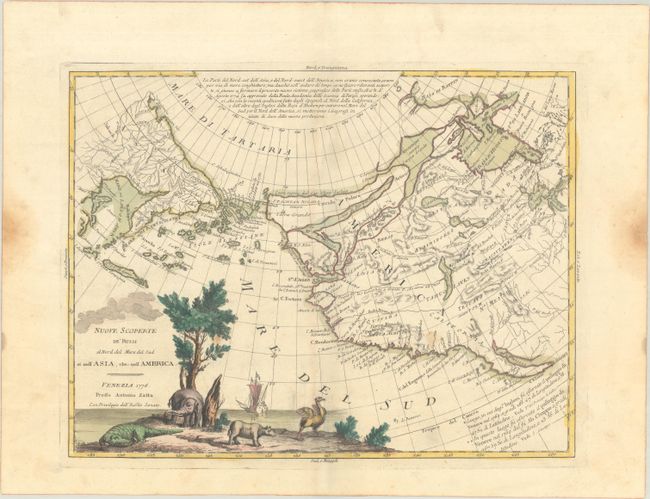
Subject: North Pacific Ocean
Period: 1776 (dated)
Publication: Atlante Novissimo
Color: Hand Color
Size:
15.8 x 12.1 inches
40.1 x 30.7 cm
A fascinating map showing the western coast of North America from the Baja Peninsula, along the coast of California to Alaska and thence to the Bering Strait and the Kamchatka Peninsula. The map presents an interesting array of hypothetical cartography. The northwest coast of North America is filled with the fictitious system of rivers and lakes of the Northwest Passage that were supposedly discovered by Admiral de Fonte. In addition to those wide passages that connect Hudson Bay with the Pacific, two rivers provide possibilities for the legendary River of the West theories. Alaska is represented by a group of islands clustered off the coast of Russia, collectively identified as Isole Alessiane. There is a notation of the legendary Chinese colony of Fou-Sang in the general vicinity of Vancouver Island. The pictorial title cartouche includes several incongruent animals - a crocodile, an elephant, a rhinoceros, and an ostrich.
References: Portinaro & Knirsch p. 250; Shirley (BL Atlases) T.ZAT-1a, Vol. 4 #42; Suarez (PAC) Fig. 21; Wagner #654; Wheat (TMW) #167.
Condition: B+
Full contemporary color with a three crescent moon watermark. There are a couple of minor spots in the image, a small area of paper weakness at lower right, and a pair of dampstains in the side margins far from the map image.