Subject: North Pacific, Northern Asia & Northwestern North America
Period: 1587 (published)
Publication: Theatrum Orbis Terrarum
Color: Hand Color
Size:
18.6 x 13.8 inches
47.2 x 35.1 cm
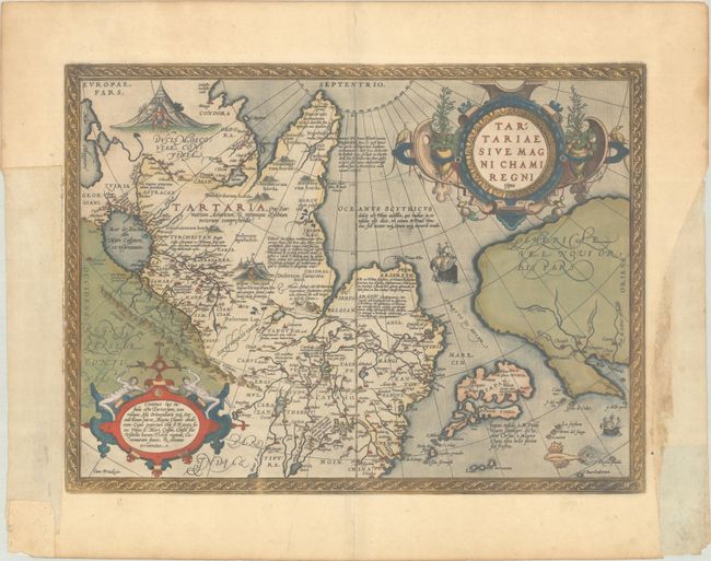
This extremely decorative map is important for several reasons and therefore becomes a foundation map for a variety of collection subjects.
It is the earliest printed map to focus on the North Pacific and the Stretto di Anian. Ortelius' depiction increased public awareness of Gastaldi's theory of a strait between the continents of Asia and America. It also includes a very early depiction of Japan, which is shown as a huge group of islands taking up nearly the entire North Pacific and located equal distance from both Asia and America. A notation reveals that Japan, called Zipangri by Marco Polo and also Chryse, was once attacked by the great Khan.
It is also one of the earliest (obtainable) maps to depict Northwestern America and to name California (C. Califormio). Six of the mythical Seven Cities of Cibola are located in the present-day Southwestern United States. This information was derived from reports of the ill-fated expedition of Francisco Vasquez de Coronado in 1541.
The map was designed to illustrate the expansive Kingdom of the Great Khan in Asia, which according to Ortelius is bounded by the river Ob, Lake Kataia, the Volga, the Caspian Sea, the river Chesel, the mountains of Usson, the area of Tibet, the river Caromora, and the Morning Ocean.
The map was beautifully engraved by Frans Hogenberg and is filled with decoration including two encampments of Tartars, sailing ships, a flying fish, and two elaborate strapwork cartouches. French text on verso with page number 92.
References: Burden #41; Van den Broecke #163; Wagner (NW) #81; Walter #11E; Wheat (TMW) #16.
Condition: A
A dark impression with full contemporary color on a bright sheet with the coat of arms watermark of Claude Denise. There are large chips confined to the blank margins that have been replaced with old paper, not affecting the map image but with small loss of the text on verso. If framed, the chips would not be visible.