Subject: Western Hemisphere - America
Period: 1765 (circa)
Publication:
Color: Hand Color
Size:
25.9 x 18.8 inches
65.8 x 47.8 cm
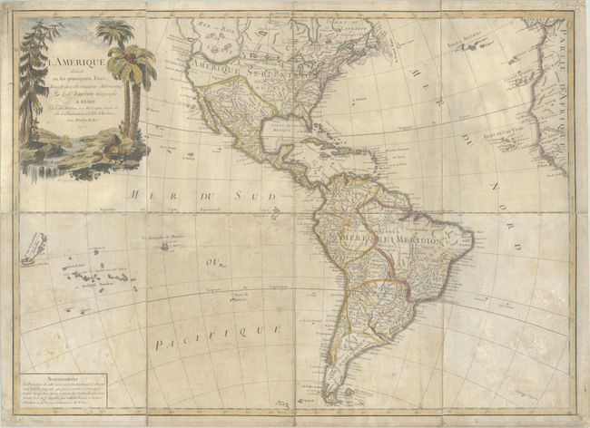
The most striking feature of this large, handsome map of North and South America is the huge Sea of the West. It is so massive that the northern portion of this mythical sea is not shown. Two entrances from the Pacific are noted: by Juan De Fuca in 1592 and by Martin d'Aguilar in 1603. It is connected by a series of rivers to Hudson Bay in the north and nearly connects to the Mississippi River in the south, thus presenting one of the most elaborate Northwest Passages of maps from this period. The balance of the map includes a myriad of information on cities, political boundaries, and river systems. The large decorative title cartouche, engraved by P.P. Choffard, shows a stream filled with unusual beaver dams and pine trees on one bank and palm trees on the other. This is the second state, dated 17-- in the cartouche. This example was dissected and mounted on linen.
References: McGuirk #88.
Condition: B
Contemporary outline color in the map with later color in the cartouche, dissected and mounted on linen. There is moderate toning and soiling, with some abrasions in the bottom corners of the sheet with minute loss of rhumb lines.