Subject: Eastern Europe
Period: 1535 (circa)
Publication: Geographiae Claudii Ptolmaei Alexandrini...
Color: Black & White
Size:
13.3 x 10.1 inches
33.8 x 25.7 cm
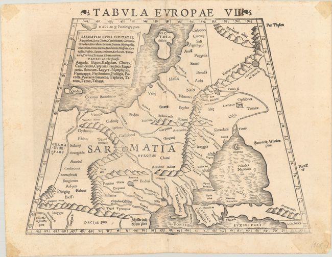
Sebastian Munster (1489 - 1552) was one of the three most renowned cartographers of the sixteenth century, along with Mercator and Ortelius. Munster's Geographia and Cosmographia Universalis were two of the most widely read and influential books of the period. His editions of Ptolemy's Geographia, published between 1540 and 1552, were illustrated with 48 woodcut maps, the standard 27 Ptolemaic maps supplemented by 21 new maps. These new maps included a separate map of each of the known continents and marked the development of regional cartography in Central Europe. The antique geography was a prelude to Munster's major work, the Cosmographia, which was published in nearly 30 editions in six languages between 1544 and 1578 and then was revised and reissued by Sebastian Petri from 1588 to 1628. The Cosmographia was a geographical as well as historical and ethnographic description of the world. It contained the maps from the Geographia plus additional regional maps and city views with nearly 500 illustrations which made it one of the most popular pictorial encyclopedias of the sixteen century.
This map covers Eastern Europe, known in ancient times as Sarmatia, encompassing the region between the Baltic and Black seas and between the Vistua and Volga rivers. The map is typically Ptolemaic - set within a trapezoidal frame with rope-like mountain ranges and broad rivers. In earlier editions of Munster's Geographica, this map is titled Tabula Europae VIII; on this example, a previous owner has amended the title in manuscript ink.
References: Mickwitz & Miekkavaara #215-10.
Condition: B
There is light dampstaining around the centerfold, light foxing, and light soiling that is mostly confined to the margins. Manuscript ink numerals have been added to the title, and there are tape stains in the corners of the sheet, well away from map image.