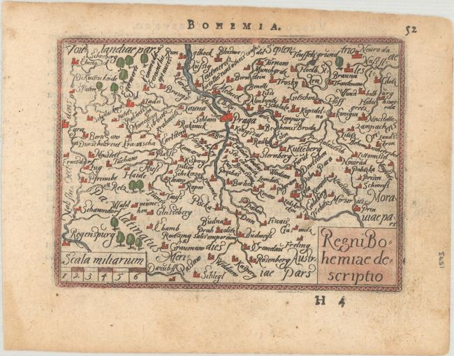
Subject: Czech Republic
Period: 1593 (published)
Publication: Theatro d'Abrahamo Ortelio
Color: Hand Color
Size:
4.3 x 3.1 inches
10.9 x 7.9 cm
Beautiful miniature map roughly centered on Prague with many tiny engraved towns and graphic depictions of forests. The title and scale of miles are enclosed in block-style cartouches. Italian text on verso.
This map is from the first pocket-sized atlas, Spieghel der Wereld, which was based on Ortelius' Theatrum Orbis Terrarum. The maps were engraved on copper by Filips Galle and represented all regions around the world. The maps were accompanied by text prepared by Peter Heyns, who used the text from the Theatrum. The numbers printed above the maps, adjacent to the letterpress title, indicate the number of the map within the Theatrum. This innovative, small atlas was designed to reach the lower middle class, and was a commercial success, prompting numerous reprints and imitations. The first edition of the Spieghel der Wereld was published in 1577, with subsequent editions published in French in 1579 and 1583, Dutch in 1583 and 1596, Latin in 1585, and Italian in 1593. One unique feature of this pocket atlas was the inclusion of 6 larger, fold-out maps of the world, Europe, France, Germania, the Low Countries, and Italy that were included alongside 66 miniature maps.
References: King (3rd ed.) #1577; Van der Krogt (Vol. III) #2850:331.
Condition: B+
There is light soiling, marginal dampstaining, and small remnants of hinge tape on verso.