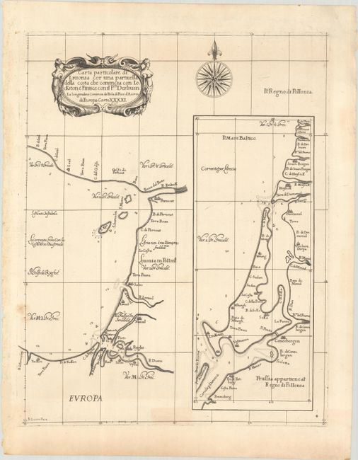
Subject: Gulf of Riga
Period: 1661 (published)
Publication: Arcano del Mare
Color: Black & White
Size:
15 x 18.9 inches
38.1 x 48 cm
This rare sea chart covers the Gulf of Riga, extending from Ryghe (Riga) and the R. Duina (Daugava River) north to Pernout (Parnu). It includes depth soundings, anchorages, hazards, and small islands. A large inset at right, Prussia Appartiene al' Regno di Pollonia, depicts the vicinity of the Vistula and Curonian lagoons, identifying cities such as Conesbergen (Kaliningrad) and Dermemel (Klaipeda). The chart is elegantly engraved with fine calligraphy, a bold strapwork title cartouche, and a compass rose by the Florentine craftsman Arnoldo Lucini. This is the second state with "Lo.6o." added to the title cartouche.
Robert Dudley was the first Englishman to produce a sea atlas, Dell Arcano del Mare (Secrets of the Sea). Dudley, a skilled mathematician and navigator, was exiled from England and settled in Florence where his atlas was published. He introduced a totally new style for sea charts in the atlas with only lines of latitude and longitude and no rhumb lines. The charts were meticulously compiled from original sources and were both scientific and accurate for the time. This important atlas was the first sea atlas of the whole world; the first to use Mercator's projection throughout; the earliest to show the prevailing winds, currents and magnetic deviation; and the first to expound the advantages of Great Circle Sailing. In an introductory leaf found in one copy in the British Library, the engraver (Lucini) states that he worked on the plates in seclusion for twelve years in an obscure Tuscan village, using no less than 5,000 pounds of copper for the printing plates. It was only issued in two editions and the maps are rarely seen on the market. The last example of this chart we have found on the market was listed in 1986.
References: Shirley (BL Atlases) M.DUD-1b.
Condition: B+
A fine impression on watermarked paper with light spots that just enter map image at left and light toning that is largely confined to the blank margins.