Catalog Archive
Auction 203, Lot 207

"Map of the Pacific Coast in the Vicinity of San Francisco, Embracing a View of the Bay Country as Seen from Mt. Tamalpais...", Railroad Companies, (Various)

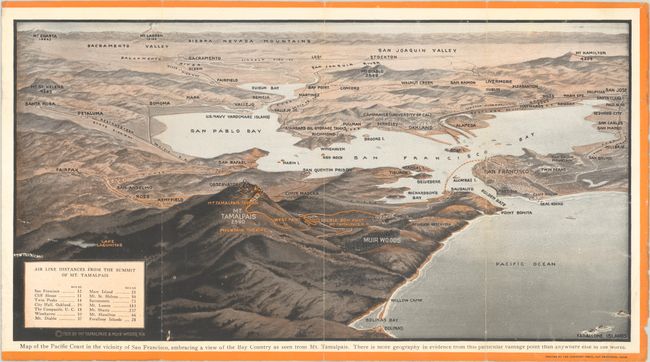
Subject: San Francisco Bay Area, California

Period: 1923 (dated)

Publication:

Color: Printed Color

Size:
15.3 x 8 inches
38.9 x 20.3 cm
Download High Resolution Image
(or just click on image to launch the Zoom viewer)

This promotional brochure promotes train service to Mt. Tamalpais and Muir Woods along the "crookedest" railroad in the world with 281 curves along the way, touting it as "America's greatest one day trip." It includes a bird's-eye view of the entire bay area from the vantage point of Mt. Tamalpais and extending out to San Jose, Sacramento, and Santa Rosa with the Sierra Nevada Mountains in the background. Produced by the Mt. Tamalpais & Muir Woods Railroad, which began operation in 1896 and closed in 1930 due in part to the growing automobile competition and the Great Depression. Self-folding into pictorial paper wrappers (4.0 x 9.0").

References:

Condition: B+

Issued folding, with light wear along the folds and a 1" chip on the back cover, not affecting the map.

Estimate: $100 - $130

Sold for: $120

Closed on 4/23/2025

Archived