Subject: Eastern United States
Period: 1820 (circa)
Publication: A Complete Genealogical, Historical, Chronological and Geographical Atlas…
Color: Hand Color
Size:
21.3 x 16.9 inches
54.1 x 42.9 cm
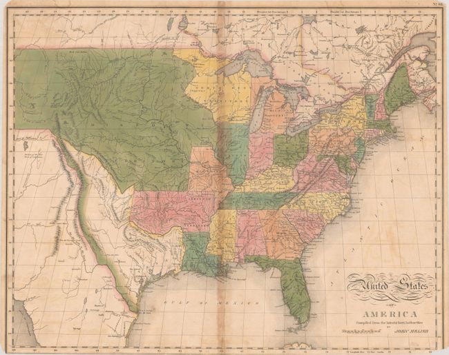
This edition of Melish's important map was engraved by Benjamin Tanner and published by Mathew Carey & Son for C. V. Lavoisne's atlas. It provides a detailed view of the Missouri River and the headwaters of the Columbia River based on information from Lewis and Clark's expedition. One of the most interesting features of the map is the river system in the West, near the Highest Peak, where the headwaters of several major rivers all originate near one another, including Red River of California (Colorado), Multnomah (Willamette), Rio del Norte (Rio Grande), Arkansaw (Arkansas), and the Platte. The new state of Missouri is shown with a straight western border. Michigan Territory includes the eastern part of present-day Wisconsin, which is still a part of the North West Territory. The large Arkansas Territory takes in most of present-day Oklahoma. Texas is separately delineated with its border with Mexico conforming to Melish's map of 1816, following the Rio Grande up to the Rio Puerco, with a dotted line that reconnects with the Rio Grande just north of Taos.
References: Wheat (TMW) #338.
Condition: B
Full contemporary color with moderate toning along the centerfold, light offsetting, and a few small dampstains along the top and bottom edge. The sheet has been trimmed at bottom, with the publisher's imprint and most of the lower neatline missing, as well as small chips in the bottom corners of the map. The centerfold has been reinforced with tape on verso, closing a 10.5" separation, and a few edge tears have been repaired with archival tape on verso.