Subject: United States
Period: 1933 (dated)
Publication:
Color: Printed Color
Size:
27.1 x 20.9 inches
68.8 x 53.1 cm
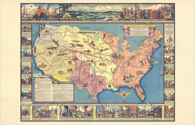
This pictorial map illustrates the "westward progress of the pioneer" in the United States from the time of the first settlers to the late 19th century. The border surrounding the map is comprised of vignettes illustrating important events in the country's history from Columbus' discovery of the New World in 1492 to the Treaty of Versailles in 1919, ending World War I. The underlying themes of these historical events are those of independence and pushing the boundary westward. The map itself is filled with additional historical notes and events and is color-coded to show how the United States expanded to the Pacific Ocean as the colonists "pushed aside the Indian owner and the white." Patriotism is another important theme in the map, with four versions of the American flag flanking the title and a compass rose in the shape of an eagle. The map shows the routes taken by land, water and rail, as well as the Oregon Trail, the Pony Express, and the trails of the Texas Longhorns. Images of frontiersmen venturing west and Native American Indians retreating westward fill the blank spaces. The map was created by August Kaiser and Clara Searle Painter, checked for historical accuracy by Agnes Larson, and published by Bureau of Engraving Inc. in Minneapolis, Minnesota.
References: Hornsby (Picturing America) #22; Rumsey #11189.
Condition: B+
A colorful example with a long tear at right (extending to St. Louis) that has been closed on verso with archival tape.