Subject: Africa
Period: 1850 (circa)
Publication: Illustrated Atlas and Modern History of the World
Color: Hand Color
The maps from The Illustrated Atlas were first published in serial form to a target audience that led insular lives due to the expense and hardship of travel. All that changed as the progress of the nineteenth century brought swift and dramatic changes in public awareness of far away places. Tallis' maps no doubt played an important role in this dramatic awakening. These maps not only provided up-to-date geographical knowledge, but also used vignette views within the map's design to show the native people and their occupations, cities and points of interest. The maps hark back to a cartographic tradition from the Dutch mapmakers of the seventeenth century with finely engraved decorative borders. The maps were drawn and engraved by John Rapkin with views drawn and engraved by a number of prominent artists. The maps were issued as a complete volume from 1851 until about 1865. Some of the maps were also published in other history books published by Tallis including British Colonies and, without the vignettes, in geographical dictionaries and encyclopedias until about 1880.
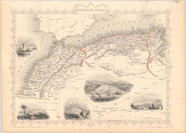
A. Northern Africa (13.1 x 9.9"). This lovely steel engraved map features a decorative border and vignettes of Mogador (now called Essaouira), Morocco, Constantine, Algiers, and Tunis. Many caravan routes are shown in the Sahara Desert, north of which is noted as Country abounding in Dates. The maritime states of Tunis, Algiers, and Morocco comprise the region known during this period as the Barbary Coast. The illustrations were drawn by H. Winkles and engraved by G. Greatbach; the map was drawn and engraved by J. Rapkin.
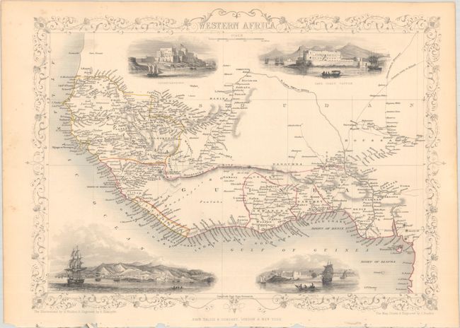
B. Western Africa (13.5 x 9.8"). This decorative map extending from Senegal to the Bight of Biafra is filled with detail and includes finely engraved vignettes of Fort Christiansborg, Cape Coast Castle, Sierra Leone, and Bakel. These vignettes were drawn by H. Winkles and engraved by E. Radclyffe; the map was drawn and engraved by J. Rapkin.
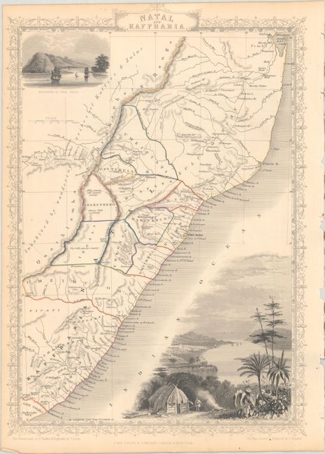
C. Natal and Kaffraria (9.8 x 14.1"). This map covers the region from the Eastern Cape province of South Africa north to Delagoa Bay. It features large vignettes of "Port Natal and Town of Durban" and "Entrance to Port Natal." These vignettes were drawn by H. Winkles and engraved by W. Lacey; the map was drawn and engraved by J. Rapkin.
References:
Condition: B+
Contemporary outline color with light toning and a few minor spots. Binding holes are confined to the far blank margins.