Subject: Antigua
Period: 1780 (dated)
Publication:
Color: Hand Color
Size:
14.9 x 14.9 inches
37.8 x 37.8 cm
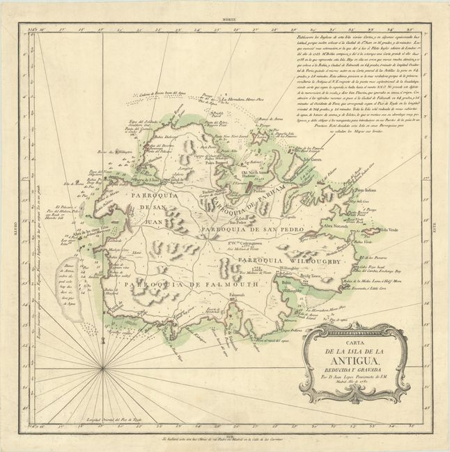
This rare chart of Antigua was published in Madrid by Don Tomas Lopez de Vargas Machuca (1730-1802), Geographer to the King of Spain and one of the most distinguished Spanish cartographers of the eighteenth century. It divides the island into five parishes: San Juan, Parham, San Pedro, Willoughby, and Falmouth. The chart identifies smaller satellite islands, towns and cities (including the capital, St. John's), mountains, rivers, bays, roads, a fishing hole, and churches. The Lucas and Codrington sugarcane plantations are noted and depicted with tiny illustrated windmills. Navigational information such as soundings, banks, anchorages, and hazards are shown. A block of Spanish text at top right discusses the mapping of the island and mentions Bellin. The decorative title cartouche appears at bottom right.
References: Shirley (BL Atlases) T.LOP-3a Vol. 2 #26; Tooley (MCC-55) #41.
Condition: A
A crisp impression on a sheet with a coat of arms watermark. There are a few minor spots in map image and a faint dampstain and short edge tear in the bottom margin, not affecting the image.