Subject: Yellowstone, Wyoming
Period: 1874 (dated)
Publication: Report upon the Reconnaissance of Northwestern Wyoming, Including Yellowstone…
Color: Printed Color
Size:
17.9 x 31 inches
45.5 x 78.7 cm
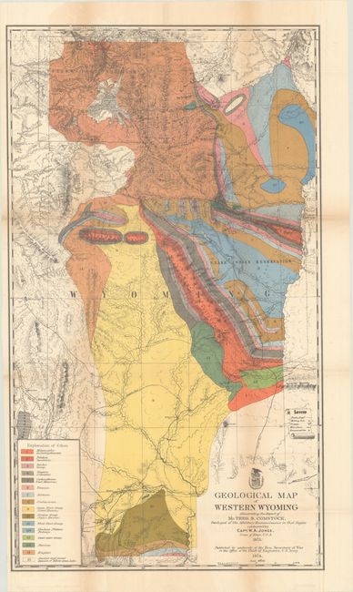
A handsome and colorful map that illustrated the report of T.B. Comstock, the geologist to the Military Reconnaissance of the region that was conducted by Capt. W.A. Jones, Corps of Engineers. This is one of the earliest geological maps of Yellowstone country based on actual exploration, preceded only by Hayden's very rare separately published Snake River and Montana, and Wyoming Territories maps (Marcou & Marcou #629 & #630). The map is color-coded to show 16 different geological types and a host of other details including topography, trails, roads, stage stations, military posts, astronomical observation stations, and the boundaries of the Snake Indian Reservation. Area includes Jackson Hole, the Big Horn and Teton Mountains, and extends south to Fort Bridger and the Sweetwater Mountains. Terrific detail of the newly formed Yellowstone Park.
References: Marcou & Marcou #631; Blevins Mapping Wyoming #256.
Condition: B
Issued folding with light toning along the fold lines. There are old tape repairs to a few fold separations on verso with related minor staining visible along one fold on recto.