Subject: Colonial North America
Period: 1677 (dated)
Publication:
Color: Hand Color
Size:
21.1 x 15.3 inches
53.6 x 38.9 cm
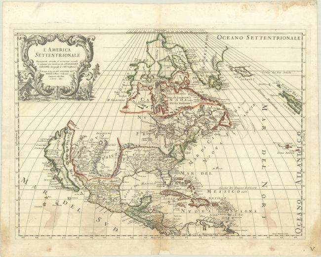
This is the uncommon, first edition of Rossi's fine map of North America, based on the seminal Sanson map of the region. As in the Sanson version, California is shown as an island on the Foxe model with two northern bays, and all five Great Lakes are shown, albeit with Superior and Michigan shown open-ended. There are many place names noted on California's coast, including Pta de Monte Rey, Canal de S. Barbara, P. de S. Diego, and Catalina Island is named I. de S. Catalina. Several Indian tribes are identified in New Mexico where the R. del Norte (Rio Grande) mistakenly flows from an interior lake near Taos (Taosji) and empties into the Mar Vermeio o Mer Rosso (Gulf of California). The political divisions favor the French point of view, with Canada and Nuova Francia covering much of the eastern half of the continent. The Arctic cartography is typical for the period, with a large, triple island in Baffin Bay, and Greenland shown on Sanson's three-island model.
References: Burden #491; McLaughlin #65.
Condition: B
A crisp impression with contemporary outline color on a bright sheet with a Pascal lamb watermark. There are dampstains entering the bottom quarter of the map, and a chip and centerfold separation at bottom center have been archivally repaired.