Subject: Southern Australia & Tasmania
Period: 1879 (dated)
Publication:
Color: Black & White
Size:
50 x 40 inches
127 x 101.6 cm
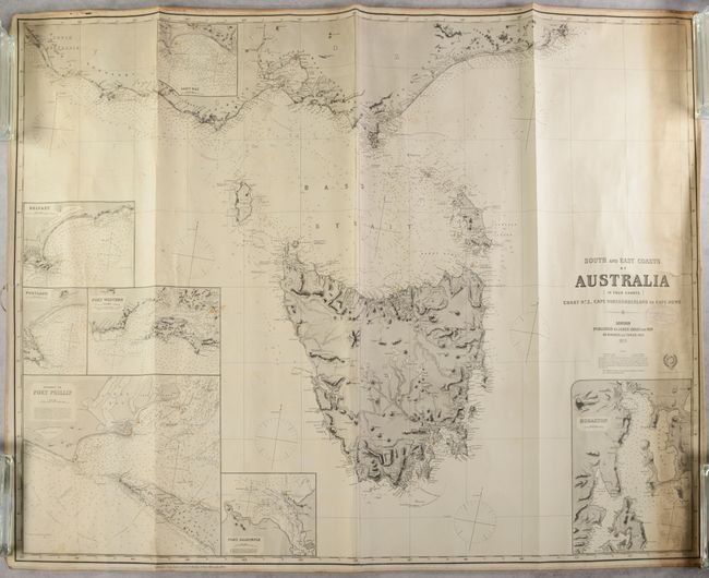
This grand two-sheet blueback nautical chart depicts part of South Australia, southern Victoria, and Tasmania. The chart shows southern Australia from Rivoli Bay to Cape Howe, with topographical detail and place names along the coast. A railway connects Melbourne to Geelong. Tasmania is rendered in fine detail with great detail of its inland terrain. The chart is teeming with navigational details including soundings, currents, hazards, magnetic variation, and more. Lighthouses are marked in original yellow and red hand coloring with radiating circles to indicate how far light can be seen at sea. Insets cover Lady Bay, Belfast, Portland, Port Western, Port Phillip, Port Dalrymple, and Hobarton. A note below the title shows Imray's devotion to accuracy: "The Publishers request communications tending to the improvement of this or any of their works." These are sheets 3 & 4 of the series, joined. The yellow title label on verso indicates it is "Chart No. 200" at a cost of 8 shillings.
References:
Condition: B
A sharp impression with toning and soiling along the right edge, faint dampstaining at bottom left, some extraneous creasing, and a 0.5" edge tear at left. The linen edging is coming loose at top left. There are some manuscript notations in pencil and pink ink. The map was stored rolled and does not lay flat on its own.