Subject: North Pacific Ocean
Period: 1794 (published)
Publication: Voyages de la Chine a la Cote Nord-Ouest d'Amerique…
Color: Black & White
Size:
22.4 x 16.8 inches
56.9 x 42.7 cm
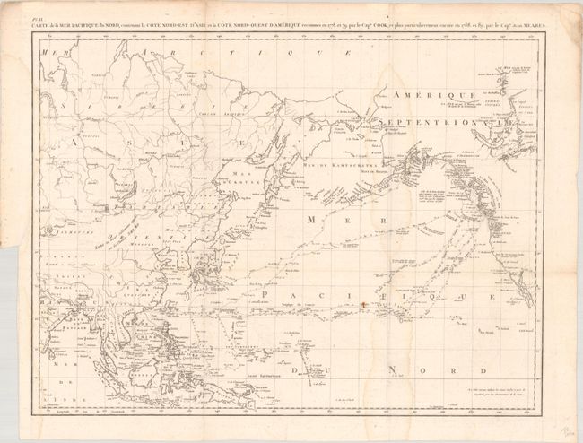
This terrific map of the North Pacific details the explorations of Captain Cook from 1778-79 and Captain John Meares from 1788-89. The map covers a good portion of the Asian and North American continents, but the primary focus is on the tracks of the various explorers through the Northwest, Alaska, Canada, Hawaii, and through the Pacific to the Philippines and Southeast Asia. Meares is one of the more colorful figures in the early European exploration of the Northwest coast and Alaska. He claimed many of the discoveries of others as his own and rekindled the idea of the Sea of the West and a Northwest Passage. His mythical inland sea appears stretching from the Strait of Juan de Fuca northwards to just north of the Queen Charlotte Islands. A note indicates that the American sloop Lady Washington captained by Robert Gray had explored this sea in 1789. This was a complete fabrication on the part of Meares; nevertheless it gave new credence to the idea and appears on several later maps as well.
References: Hayes pp. 59-61; Kershaw #1172; McGuirk #216; Shirley (BL Atlases) G.MEAR-2a #1; cf. Wagner #759.
Condition: B
A nice impression issued folding on a bright sheet with a medallion watermark. There is light dampstaining along the edge of the map at left and along the folds at right. There is a small rust spot, minor foxing and offsetting, and a binding trim at left with an associated tear that has been closed on verso with archival tape and just brushes the neatline at left.