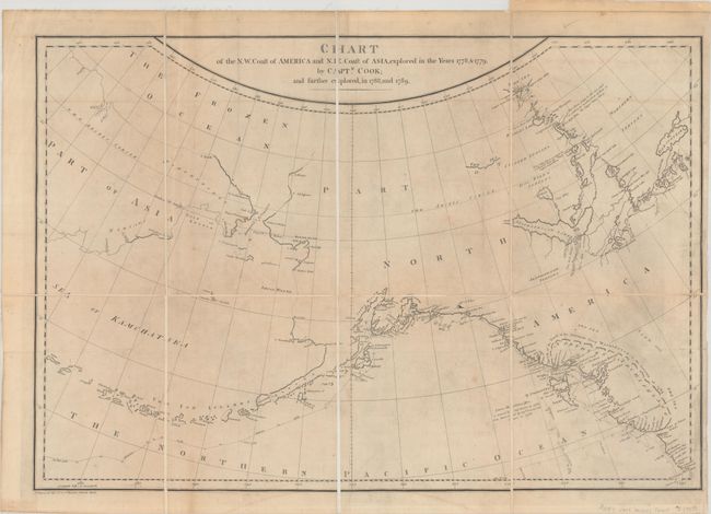
Subject: North Pacific Ocean
Period: 1790 (circa)
Publication: Voyage Made in the Year 1788 and 1789, From China to the North West Coast of America...
Color: Black & White
Size:
25.1 x 17.1 inches
63.8 x 43.4 cm
This is the scarce English edition of this interesting map of Alaska and the Bering Strait detailing the explorations of Captain John Meares. As noted in the title, the map shows the region explored by Captain Cook, but the primary focus is on the tracks of Meares' voyage in 1788-89, ten years after Cook's expedition. Meares is one of the more colorful figures in the early European exploration of the Northwest coast and Alaska. He claimed many of the discoveries of others as his own and rekindled the idea of the Sea of the West and a Northwest Passage. His mythical inland sea, Northern Archipelago, appears stretching from the Strait of Juan de Fuca northwards to just north of the Queen Charlotte Islands, although it is not completely delineated. A note indicates that the American sloop Lady Washington, captained by Robert Gray, had explored this sea in 1789. This was a complete fabrication on the part of Meares; nevertheless it gave new credence to the idea and appears on several later maps as well. Drawn by J. Haywood. This example has been dissected and mounted on linen.
References: Falk #1790-18; Kershaw #1161; McGuirk #204; Shirley (BL Atlases) G.MEAR-1a #3; Wagner #758a.
Condition: B
Issued folding, now dissected and mounted on linen. There is light toning and soiling, minor offsetting, and a 3" binding tear at right that has been archivally repaired on verso.