Subject: Greece
Period: 1552 (published)
Publication: Geographia
Color: Black & White
Size:
14.7 x 11.2 inches
37.3 x 28.4 cm
Sebastian Munster (1489 - 1552) was one of the three most renowned cartographers of the sixteenth century, along with Mercator and Ortelius. Munster's Geographia and Cosmographia Universalis were two of the most widely read and influential books of the period. His editions of Ptolemy's Geographia, published between 1540 and 1552, were illustrated with 48 woodcut maps, the standard 27 Ptolemaic maps supplemented by 21 new maps. These new maps included a separate map of each of the known continents and marked the development of regional cartography in Central Europe. The antique geography was a prelude to Munster's major work, the Cosmographia, which was published in nearly 30 editions in six languages between 1544 and 1578 and then was revised and reissued by Sebastian Petri from 1588 to 1628. The Cosmographia was a geographical as well as historical and ethnographic description of the world. It contained the maps from the Geographia plus additional regional maps and city views with nearly 500 illustrations which made it one of the most popular pictorial encyclopedias of the sixteen century.
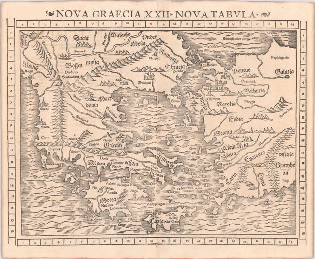
This early double-page woodblock map shows Greece, the Aegean Sea, and western Turkey, focused on the Dardanelles, which separates Europe from Asia. First published in Munster's Cosmographia in 1544, it is the first map of Greece based on contemporary sources; this example was published in his 1552 edition of Ptolemy's Geographia. It locates Athens, Constantinople, Arcadia, Crete, Rhodes, Byrsa (Bursa), and more, extending to show part of the Black Sea. Troia (Troy) is on the coast near Lesbos Island. Major rivers are named, and mountains are in the style of a Ptolemaic map. The map is surrounded by a printed border of bars representing latitude and longitude. Latin text on verso.
References: Mickwitz & Miekkavaara #215-50; cf. Zacharakis #1579.
Condition: A
A dark impression with a bit of minor foxing at right and a small hole in the border at bottom.