Subject: North Pole
Period: 1714 (published)
Publication: Atlas Soulage
Color: Hand Color
Size:
8 x 5.8 inches
20.3 x 14.7 cm
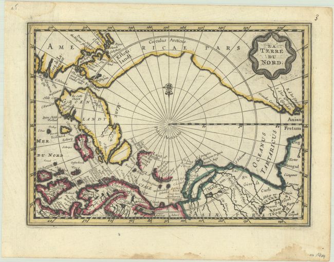
This is the second state of this small map of the North Pole, with a new title cartouche with the title changed from Septentrionalium Terrarum Descript, the North Atlantic renamed Mer du Nord, and the addition of a compass rose. The map was originally created by Jansson for his Atlas Minor. It does not follow Mercator, instead using as a source the many contemporary exploratory voyages that attempted to locate a northern route to Asia. Several fictitious islands, including Frisland, appear in the North Atlantic. Novaya Zemlya is connected to the Russian mainland, and Spitsbergen is depicted as two oversize coastlines.
This is an extremely rare variant of a map first published in Jansson's new Atlas Minor in 1628. Van der Aa acquired the copperplates in the early 18th century for use in his Nouveau Petit Atlas, which was published circa 1714. The atlas was composed of nine parts, with the general portion falling under Nouveau Petit Atlas and then 8 individual regional parts under the title Atlas Soulage. Van der Aa revised the plate by updating the title cartouche (in French with a new border) and making other small changes. The atlas was only issued once and there is only one known complete copy extant, in the University Library of Leiden.
References: cf. Burden #222; Van der Krogt (Vol. III) #0020:352.2.
Condition: A
A dark impression with contemporary outline color on a bright sheet with light printer's ink residue. There is a small dampstain adjacent to Novaya Zemlya, and several additional dampstains along the edges of the sheet.