Subject: Western Mexico, Central America & South America
Period: 1728 (published)
Publication: Atlas Maritimus & Commercialis...
Color: Hand Color
Size:
23.7 x 20.1 inches
60.2 x 51.1 cm
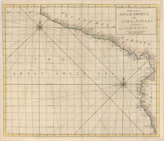
This rare sea chart covers the Pacific coast of Mexico, Central America, and South America from Cabo Corrientes in Jalisco south to Lima, Peru. Along the coast are place names, including Acapulco, Puerto Escondido, Guatemala City, Panama Bay, Guayaquil, Trujillo, Lima, and numerous volcanoes, capes, and bays. Mexico City is the only inland city identified. The Galapagos are partly obscured by one of the map's two ornate compass roses. The chart's Great South Sea is crisscrossed by rhumblines. It was published in Atlas Maritimus & Commercialis, an atlas with several joint publishers, among them James and John Knapton, William and John Innys, and John Senex. Senex is often credited with preparing the various charts therein. Most likely engraved by Samuel Parker, who is credited on other charts in the atlas. According to Shirley, the atlas is often catalogued under Astronomer-Royal Edmund Halley, who contributes an introductory note on the projection used throughout the atlas.
References: Phillips (Atlases) #3298-52; Shirley (BL Atlases) #M.HALL-1a #52.
Condition: B+
A nice impression with light foxing and toning, and a couple tiny wormholes that are only visible when held up to light.