Subject: Southwestern United States
Period: 1858 (published)
Publication:
Color: Hand Color
Size:
17.8 x 7.8 inches
45.2 x 19.8 cm
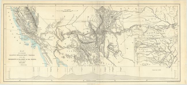
This relatively small but detailed map was issued in Baldwin Mollhausen's Diary of a Journey from the Mississippi to the Coasts of the Pacific. After participating in an expedition to Fort Laramie with the Duke Paul Wilhelm of Wurttemberg in 1851, Molhausen was hired as a topographer for the Pacific Railroad Survey along the 35th parallel under the direction of Lieutenant Whipple. The map covers the region from Ft. Smith, Arkansas to Los Angeles and shows the party's route through the region along with good detail of the river systems, topography, forts, and Indian tribes. The newly acquired Gadsden Territory is identified in southern Arizona, with the U.S. having purchased the area from Mexico in 1854. In addition to the main map, there is an inset of the south central United States and an elevation profile of the route. Engraved by Edward Weller. This is the only map included in Mollhausen's book, which was published in German, Danish, Dutch and English. Howes describes Mollhausen's volume as "the best account."
References: Howes #M-713; Sabin #49915.
Condition: B+
Issued folding on a clean sheet with a couple of short archivally repaired fold separations. The right panel of the folding map fully separated along the fold and has been skillfully reattached on verso with archival tape.