Subject: Minnesota & South Dakota
Period: 1858 (dated)
Publication: Sen. Doc. 36 or H.R. Doc. 108, 35th Congress, 2nd Session (Campbell's Wagon Roads)
Color: Black & White
Size:
32 x 18.5 inches
81.3 x 47 cm
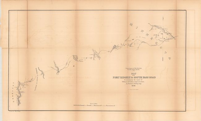
This highly detailed map delineates the 255-mile long road between Fort Ridgely westward to the Missouri River around today's Chamberlain, South Dakota. The route heads west, initially following the Cotton Wood River. It passes by Lynd's Trading Post, Old Indian Fortifications, the Plateau du Coteau du Misouri, and crosses Red Wood Creek, Big Sioux River, Wolf Branch of Morse's Creek, Dacota or James River, and Wessington Springs. It locates the Lower Sioux Agency, New Ulm, Tuttles Winter Quarters with a nearby Indian Village, and Agency Mills. The completion of the road was hampered by prairie fires and by the Yankton Sioux demanding compensation. Drawn by John R. Key for Samuel A. Medary, Engr. to accompany the report of William H. Nobles, Superintendent. Lithographed by the Philadelphia firm of T.S. Wagner.
Carl Wheat devotes a chapter to the Wagon Road project, concluding "The Department of the Interior was caught up in the currents that surrounded the oncoming Civil War, and little came of the imposing wagon road program that it had set in motion. [However] its efforts were of great effect on all parts of the West."
References: Wheat (TMW) #987.
Condition: B
Issued folding and now flattened and backed with tissue to reinforce and repair some short splits at the fold junctions and two edge tears along the upper horizontal fold at left and right. There is toning along the folds and minor offsetting.