Subject: World
Period: 1720 (circa)
Publication:
Color: Black & White
Size:
11.9 x 8.9 inches
30.2 x 22.6 cm
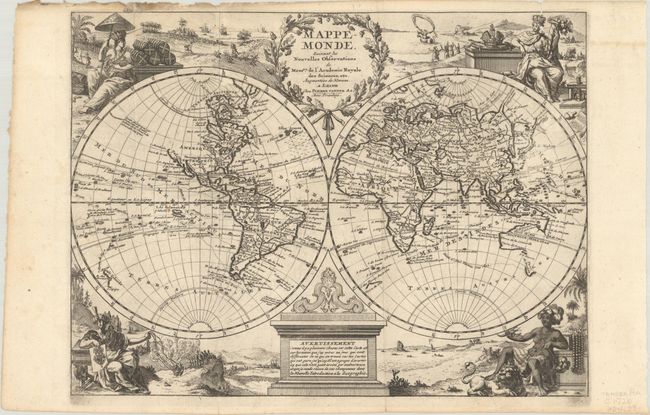
Vignettes symbolizing the four continents fill the corners of this uncommon, double hemispheric world map. The map illustrates the routes of several sixteenth century explorers in the Pacific and Indian Oceans, including Magellan, Tasman, Chevalier de Chermont, Mendana and others. The western coastline of New Zealand is illustrated, along with parts of Australia and Tasmania. The entire northwest coast of North America is blank above the peninsular California. There is a remnant of the coastline that suggested a connection between North America and Asia on earlier maps; here with a notation concerning the discoveries of Vasco de Gama. The eastern coast of Asia is truncated and a huge Terre d'Yeco forms the northern part of Japan. The title cartouche at top is balanced with a monument cartouche at bottom explaining that the changes made on the map are explained in La Nouvelle Introduction a la Geographie.
References:
Condition: B+
A dark impression on a bright sheet, issued folding with two small worm holes in the image at top and a small hole along one of the folds. There is soiling along the top edge of the sheet along with some small chips and tears.