Subject: World
Period: 1720 (circa)
Publication:
Color: Hand Color
Size:
21.9 x 19.1 inches
55.6 x 48.5 cm
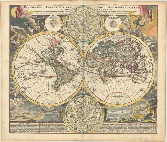
This is one of the most decorative eighteenth century world maps. The two hemispheres are surrounded by vivid engravings of natural phenomena such as a rainbow, earthquakes, and a volcano. Wind heads occupy the starry heavens, and two putti hold the title banner aloft. The map itself shows a typical geographical view of the period. An indistinct Terra Esonis appears above California, here depicted as a peninsula. The partial coastlines of Australia, New Zealand, and New Guinea are noted. Australia is shown to be separate from New Guinea, Carpentaria and Van Diemen's Land. Nova Britannia is shown as a separate island off the coast of New Guinea with the notation that it was discovered by Dampier in 1700. Several explorer's tracks are traced, including Magellan, Dampier, Tasman, Gaetani and Charmont. Nestled between the hemispheres are two detailed celestial maps. Text panels at bottom describe the natural phenomena. Homann borrowed both the cartography and depictions of natural phenomenon from Zurner's similar map circa 1700.
References:
Condition: A
A sharp impression with contemporary color in the map and later color in the decorative surround, on a bright sheet with Sebastian Heerdegen's watermark (heart-shaped with the initials SHD). There is marginal soiling and a tiny centerfold separation at bottom.