Subject: North Pole
Period: 1639 (circa)
Publication: Nouveau Theatre du Monde
Color: Hand Color
Size:
19.5 x 17.1 inches
49.5 x 43.4 cm
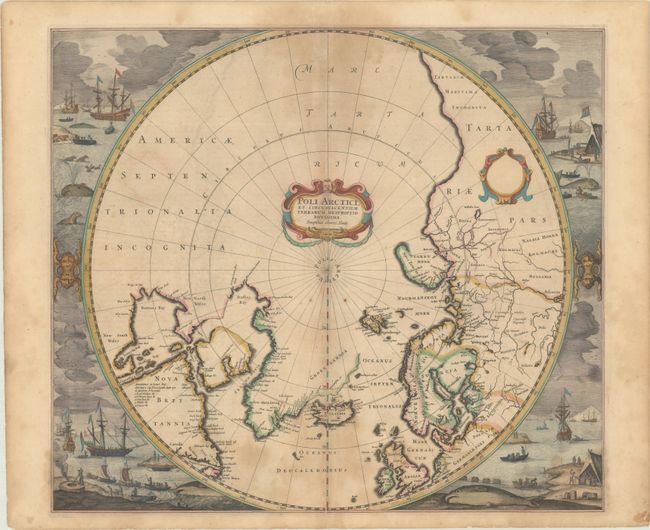
Hondius' important map of the polar region is one of the most decorative maps of the North Pole. It replaced Mercator's map in the Mercator/Hondius atlases in 1636, and incorporated much of the knowledge gained by the English in their search for a Northwest Passage to Asia. The cartography is based on Henry Briggs' depiction of Hudson Bay, showing a pair of bays in the bottom of Hudson Bay named Iames his Bay and The Great Bay of God's Deliverance. There are more names based on Hudson's explorations, including the note of Ne Ultra in an inlet at the top if the bay indicating that they could go no further there. There are several Dutch names in Labrador, many appearing for the first time on this map. The fascinating whaling scenes that surround the map also depict Dutch activity in the region. There are many types of ship and boats shown, as well as whales, seals and cormorants. Burden's third state (Kershaw's second state), the first with the whaling scenes. French text on verso, published between 1639-46.
References: Burden #246; Kershaw #100; Van der Krogt (Vol. I) #0020:1B.
Condition: B
A sharp impression with full contemporary color, scattered dampstains, a tiny abrasion at bottom center, and a few small spots. There are archival repairs to a short centerfold separation at bottom and some tiny edge tears.