Subject: New England Coast
Period: 1865 (dated)
Publication:
Color: Black & White
Size:
32.4 x 37 inches
82.3 x 94 cm
The Office of Coast Survey is the oldest U.S. scientific organization, dating from 1807 when Congress directed that a "survey of the coast" be carried out. By 1836, it was called the U.S. Coast Survey and in 1878, the name was changed to the U.S. Coast and Geodetic Survey. Today the Office of Coast Survey is a division of the National Oceanic and Atmospheric Administration NOAA.
The survey teams, composed of civilians as well as Army and Naval officers, charted the nation's waterways and produced a wide array of reports, survey charts, hydrographic studies of tides and currents, astronomical studies and observations, and coastal pilots. These charts are an important record of the changing nature of the nation's coastlines. In additional to coastal charts, the U.S. Coast and Geodetic Survey produced land sketches, Civil War battle maps, and the early aeronautical charts.
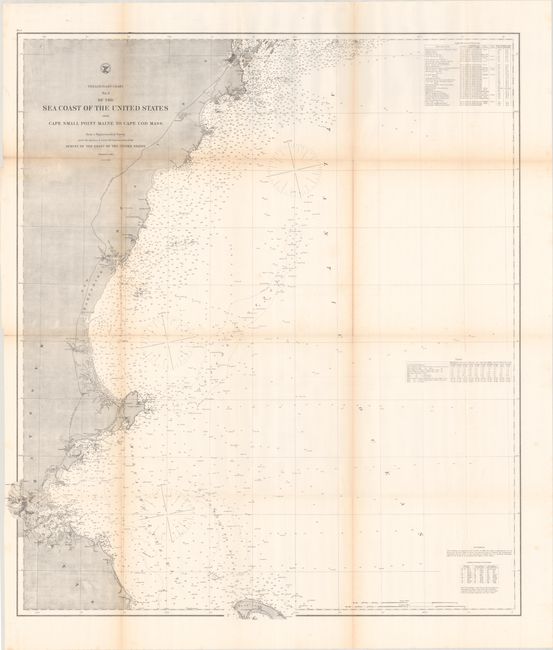
A very detailed chart issued shortly after the conclusion of the Civil War that extends from Portland, Maine south to Boston and east to the northern tip of Cape Cod. There is particularly good detail in the vicinity of Massachusetts Bay, extending from Salem south to Scituate. Street grids of the larger towns and cities are also depicted. The chart features extensive navigational information including soundings, bottom types, tides, lighthouses and much more.
References:
Condition: A
Issued folding on a clean sheet with a few short splits at the fold junctions and a hint of toning along the folds. The scanned image makes the toning appear more prominent than it actually is on the physical map.