Subject: United States
Period: 1844-87 (circa)
Publication:
Color:
This lot features three maps locating Indian tribes in 19th century America:
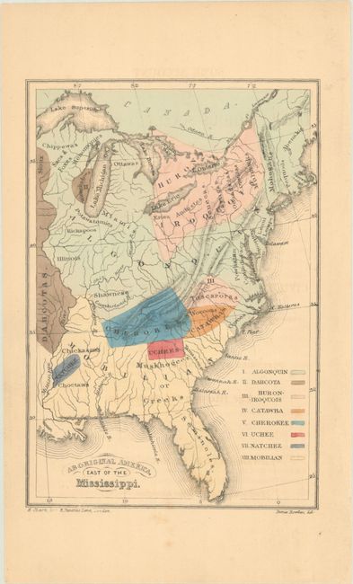
A. Aboriginal America, East of the Mississippi, by James Bowden, from Some Account of the Conduct of the Religious Society of Friends Towards the Indian Tribes, published 1844, hand color (4.4 x 6.4"). This small map shows the United States to the Mississippi River and names the known tribes and locations, with a color key at right that identifies the Algonquin, Dahcota, Huron-Iroquois, Catawba, Cherokee, Uchee, Natchez, and Mobilian Indians. It served as the frontispiece in Some Account of the Conduct of the Religious Society of Friends Towards the Indian Tribes..., published by the Aborigines' Committee of the Meetings of Sufferings in London, 1844. The Quakers held these meetings every year, in which they focused on the wrongs suffered by aboriginal peoples all over the world. Condition: Lightly toned with a few spots of foxing at bottom. (B+)
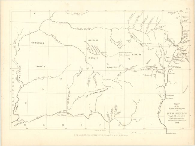
B. Map of the South Western Part of New Mexico Compiled from the Latest Explorations, by Capt. S. Eastman, dated 1853, black & white (11.4 x 7.6"). This small map extends from the Rio Grande west to the Colorado River and locates the river systems and Indian tribes in the region. Identifies the "Seven Moqui Towns" and other tribes including the Cosninas, Yampais, and Navajos. Published by Lippincott, Grambo & Co. in Philadelphia. Condition: Clean and bright. (A) Reference: Wheat (TMW) #781.
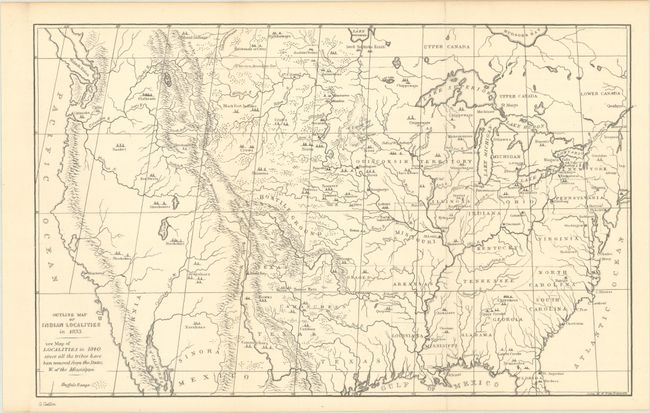
C. Outline Map of Indian Localities in 1833, by George Catlin, circa 1887, black & white (13.2 x 8.1"). This map was issued in a later edition of Catlin's Indian Gallery. It names scores of Indian villages, designated by tepee symbols. The map extends well into Canada, locating numerous Canadian tribes. There is good detail of watersheds and the known mountain ranges. The West is mostly blank and contains erroneous information in the Great Basin region derived from Fremont's map, including an east-west flowing river. An Independent Texas is shown with its northern border extending well into the Rocky Mountains, but it is indistinct at its upper reaches. Of special interest is the depiction of the Buffalo Range that stretches throughout the entire plains region and even into Mexico. The entire Midwest north of the Arkansas River and Texas is labeled "Hostile Ground." Condition: Issued folding on a clean sheet. (A)
References:
Condition:
See description above.