Subject: Prince Edward Island, Canada
Period: 1781 (circa)
Publication: The Atlantic Neptune
Color: Hand Color
Size:
30 x 41.1 inches
76.2 x 104.4 cm
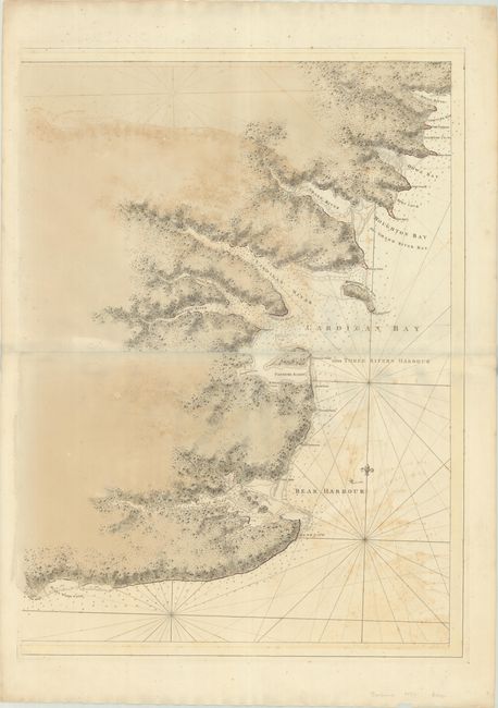
These are the eastern sheets of Des Barres' rare and massive four-sheet chart covering the southeastern coast of Prince Edward Island. It extends from Woods Island east to Cape Bear and travels along the coast as far north as Rollo Bay (named after the Scottish commander who expelled the French Acadians from the island during the French and Indian War). Intricately engraved topographical detail lines the coasts; otherwise, there is no inland detail. Soundings fill the waters. Place names include Munay Islands and river (Murray River), Panmure Island, the Three Rivers, and Boughton Bay alias Grand River Bay. Surveyed by Samuel Holland. The title cartouche appears on the western sheet and is dated 1781. Two sheets joined, as issued. Pale-wash-tinted with pale yellow borders, as issued.
Joseph Des Barres was a military engineer with the British Royal American Regiment. At the conclusion of the French and Indian war, he surveyed the coastlines of Nova Scotia, Newfoundland, and the Gulf of St. Lawrence. Upon his return to London in 1774, the Royal Navy assigned him the task of producing an atlas of new, accurate sea charts of Britain's empire in North America. In addition to his charts of the Canadian waters, he compiled the manuscripts of British cartographers in the American Colonies, Jamaica, and Cuba and produced one of the most important sea atlases of the era, The Atlantic Neptune, published between 1777 and 1781. It contained the first systematic survey of the east coast of North America, consisting of four volumes and over 250 charts and views. All the charts were immensely detailed, featuring both hydrographical and topographical information.
References: Phillips (Atlases) #1204-12; Shirley (BL Atlases) M.DES-1d #10.
Condition: B
A crisp impression with contemporary wash color. There is moderate offsetting, light scattered foxing, and some short edge tears and small chips along the sheet's edges, well away from map image.