Catalog Archive
Auction 195, Lot 115

Persuasive Map Shows New Route to the Canadian Plains from England

"[Map in Booklet] Map of the Dominion of Canada, Shewing the Extent and Situation of Its Public Lands, Also Its Geographical Relation to the British Islands [in] A New Route from Europe to the Interior of North America...", Lovell, John
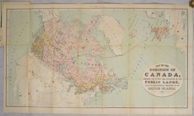
Subject: Canada

Period: 1881 (published)

Publication:

Color: Printed Color

Size:
33.1 x 18 inches
84.1 x 45.7 cm
Download High Resolution Image
(or just click on image to launch the Zoom viewer)

This 19-page brochure was printed by John Lovell & Sons and published by the Nelson Valley Railway and Transportation Company of Montreal. It features a map, lithographed by the Burland Lithography Company, that uses a polar projection to make the railroad’s case that the Churchill Harbor on Hudson’s Bay is closer to Liverpool than Montreal or New York. The company blamed the Hudson’s Bay Company for thwarting the development of the fertile Canadian Northwest to keep it a hunting ground for its Indian suppliers. Printed wrappers (5.5 x 8.3") with gilt title on the front wrapper.

References:

Condition: B+

The folding map has some light color offsetting at bottom and a bit of foxing. Text is lightly toned. Paper wrappers have tiny edge chips and a short edge tear at the top of the front wrapper.

Estimate: $200 - $250

Sold for: $100

Closed on 11/15/2023

Archived