Subject: North America
Period: 1787 (circa)
Publication: A New Royal Authentic and Complete System of Universal Geography
Color: Black & White
Size:
17 x 10.4 inches
43.2 x 26.4 cm
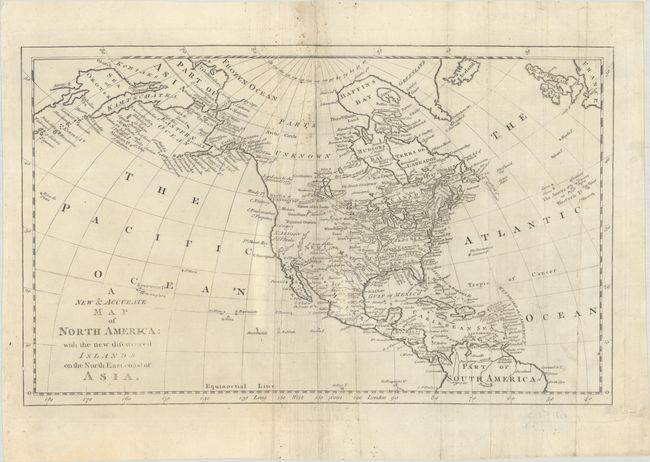
This is the first state of this map of North America focusing on the discoveries of Captain Cook in the Pacific Northwest and Alaska. Alaska is fairly well formed, although much of the Aleutian Island chain is depicted as a peninsula. Northern Canada is marked Parts Unknown, and northern California is New Albion. The northeast coast of Asia is depicted with a well formed Kamtschatka Peninsula. New Mexico encompasses present-day Louisiana and Texas, while the eastern seaboard states all extend to the Mississippi River. On the continent, the political divisions are delineated by dotted lines, and numerous Indian nations are located. Although there is no engraver's signature, Thomas Bowen is known to have prepared the maps for Bankes's New System of Geography.
References: McCorkle (18th C. Geography Books) #11-8; Shirley (BL Atlases) T.BANK-1a #8.
Condition: B+
There is some minor soiling along the centerfold and an archivally repaired centerfold separation at top that extends 3" into the image. Some extraneous creasing around the centerfold and at right has been pressed flat.