Subject: Colonial North America
Period: 1764 (circa)
Publication:
Color: Black & White
Size:
11.7 x 7.4 inches
29.7 x 18.8 cm
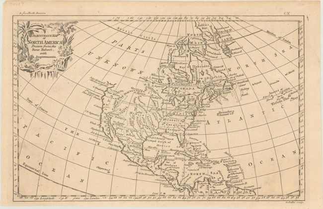
This uncommon map is after Robert de Vaugondy's larger map of North America and features a decorative title cartouche. It illustrates the continent after the conclusion of the French and Indian War. The colonies of Virginia, North and South Carolina, and Georgia are named and each extends fully to the Mississippi River. Georgia occupies Florida's panhandle. Much of the west contains erroneous mountain ranges. California is named with New Albion in its northern reaches. Quivira is in the area of today's Montana and the Dakotas with the large blank area above simply labeled Parts Unknown. Texas is Senis. The 1603 discovery of Martin d'Aguilar is shown north of Cape Mendocino with an open inlet holding out the belief in a Northwest Passage. Originally published in John Barrow's A New Geographical Dictionary, the map later appeared in geography books like Daniel Fenning's A New System of Geography (1764-69) and Richard Brookes' The General Gazetteer (1766); this is from one of the later publications.
References:
Condition: A
A nice impression with faint toning and a touch of soiling.