Subject: World
Period: 1853 (circa)
Publication:
Color: Hand Color
Size:
49.8 x 25.8 inches
126.5 x 65.5 cm
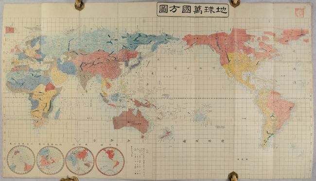
This striking Japanese woodblock map presents the world on Mercator's Projection. Countries are shown in various hand colors with an emphasis on physical features including topography and drainage. Numerous place names are identified along the coastlines throughout, with additional inland detail located in Japan, Korea and China. In North America, the map takes a British perspective, with the entire Pacific Northwest shown as a British possession. In the Pacific, Australia is noted as both New Holland and Australia. Inset maps at lower left present the polar regions (with no trace of Antarctica), eastern hemisphere, and western hemisphere. A legend at bottom center lists administrative regions and geographic features including lakes, rivers, and mountains. No publisher or creator is noted, though the stamp in the upper right corner suggests the map previously belonged to a Buddhist temple library in Japan. Self-folding (6.3 x 9.5") into paper boards.
References:
Condition: B+
Issued folding with several fold separations, primarily at lower left, that have been closed on verso with Japanese paper. There is minor loss along the horizontal fold in and around southern Africa and some occasional light soiling. Cloth covers are scuffed and worn.