Subject: Colonial New England & Mid-Atlantic United States
Period: 1645 (circa)
Publication: Nieuwen Atlas...
Color: Hand Color
Size:
19.9 x 15.3 inches
50.5 x 38.9 cm
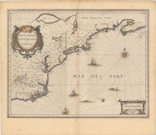
This is the first state of Jansson's important map of the eastern coast of North America covering from just south of the outer banks in present-day North Carolina to Nova Scotia. The map is based on the less well-known map of Johannes de Laet of 1630, but covers a slightly larger area. Because of its wider distribution, Jansson's map was much more influential, particularly with its depiction of the Dutch of Nieuw Nederland (New York). Cape Cod, Lake Champlain, Long Island, and the Chesapeake Bay are easily recognized compared to earlier maps. In fact, this map contains some of the earliest accurate cartography of the region showing New Amsterdam, Manhattan Island (Manbattes), Fort Orange, the Hudson (Noordt Rivier), and the Delaware (Zuydt Rivier). The map includes part of the Great Lakes, labeled Grand Lac and Lac des Yroquois, an unnamed Lake Champlain, and a fictitious lake at the headwaters of the Delaware River. According to Karpinski, this "is the first printed complete map of Lake Superior" although according to Burden there is no evidence to support that and Grand Lac is more likely Lake Huron. The map is adorned with two decorative cartouches, ships, sea monsters, and compass roses. Dutch text on verso, published between 1645-58.
References: Burden #247; Cumming (SE) #39; Karpinski, p. 26 & 31 plt. II; McCorkle #636.2; Van der Krogt (Vol. I) #9310:1A.1.
Condition: B+
A crisp impression with full contemporary color. There is light foxing, minor toning along the sheet edges, and remnants of old tape along the top edge on verso.