Subject: Eastern United States, Texas
Period: 1827 (dated)
Publication:
Color: Hand Color
Size:
60 x 51 inches
152.4 x 129.5 cm
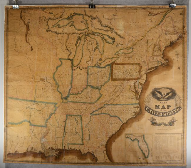
This is the scarce first edition of Lay's impressive wall map of the young United States, issued at a time of both rapid development and westward expansion. It extends to beyond the Missouri River and features a huge Missouri Territory dominating the northern Great Plains. The state of Missouri is also depicted with a flat border, prior to the Platte Purchase (1837), and a large "Military Bounty Land" is located just above Jefferson. To its east is North West Territory encompassing all of Wisconsin and eastern Minnesota as well as Michigan Territory. Directly to its south is Arkansas Territory at its largest extent and Texas prior to independence with Austin's Settlement (presumably San Felipe de Austin) erroneously located on the east bank of the Colorado River. This is one of the earliest printed maps to name Austin's Settlement and predates his seminal map of 1830. In addition to states and territories, large tracts of lands designated for the Cherokee, Choctaw, and Chickasaw tribes are identified in Alabama, Mississippi and Arkansas. In far western Mississippi, the infamous "Yazoo Purchase" is also identified. Along the western edge of the map, Stephen Long's route from St. Louis to the Rocky Mountains is shown, as well as the "Route of the Traders from Missouri to New Mexico." It features an inset map of Florida Territory and population tables as of 1820, which notes the total U.S. population at 9.6 million in addition to nearly half a million Native Americans. The handsome map is decorated by an elaborate title cartouche featuring the United States seal at top and two cornucopias at bottom. Engraved by Throop & Chapin in New York. Several later editions followed this map including 1829, 1830, 1832, 1833, 1834 and 1836. Rollers not present.
References: Streeter (Texas) #1094.
Condition: C+
Contemporary outline color with browning of the pigment. There is light toning due to the varnish, some light creasing throughout, a couple of small tears in the image, and a 2" x 2" section of loss along the lower Mississippi River. There are a few dampstain and several short edge tears mostly at top and along the upper side margins. In the blank margins, there are edge chips mostly at top and tiny staple holes along all the sheet edges from a previous framing. No rollers are present.