Subject: Eastern United States
Period: 1784 (dated)
Publication: Atlas Geographicus Maior
Color: Hand Color
Size:
22.6 x 17.6 inches
57.4 x 44.7 cm
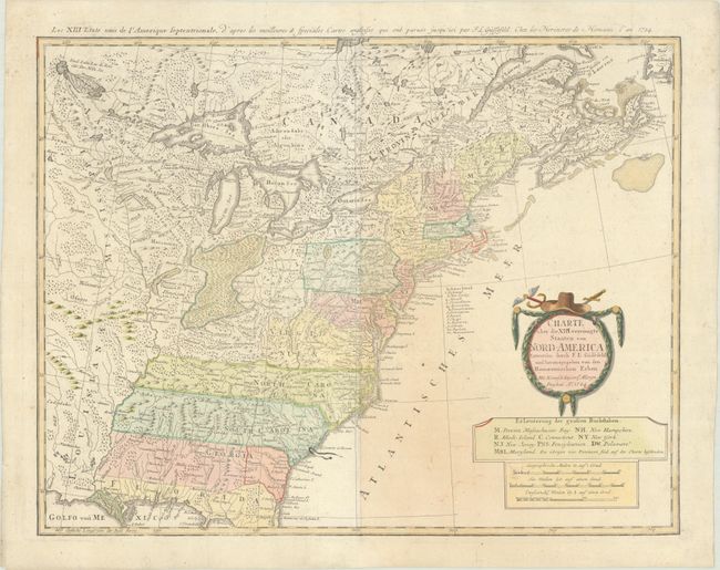
This very early and under-appreciated German map of the newly formed United States of America delineates the thirteen newly formed states. The map extends west past the Mississippi River and north to the southern tip of Hudson Bay, but the focus of the map is on the United States. The southern states are shown with their western boundaries on the Mississippi River. The lands to the West of the Mississippi River are labeled as either Louisiana or Mississippi. A note in Kentucky locates Walker's Establissement 1750, Massachusetts here is the Province of Massachusetts Bay, and neither Maine or Vermont have been organized. As with many German maps of the period, there are some incorrect state boundaries; Vermont is shown as part of New Hampshire, and Maryland includes much of northern Virginia. Principal German communities in New York, New Jersey, and Pennsylvania are listed. The interior regions are shown with considerable topographical detail, locating numerous Indian tribes and watershed. The garland-style title cartouche is topped with a hat and crossed swords. The French title is outside the top neatline: Les XIII Etats Unis de l' Amerique Septentrionale…
References: McCorkle #784-7; Sellers & Van Ee #757.
Condition: B+
Contemporary color in the map with later color in the title cartouche, on a sheet with a large "4" watermark and light toning to the right of the centerfold. There is an ink stain along the coast of South Carolina, a bit of color offsetting, and professional repairs to some minor separations along the centerfold.