Subject: Spitsbergen
Period: 1625 (circa)
Publication: Purchas His Pilgrimes
Color: Black & White
Size:
13.1 x 11.6 inches
33.3 x 29.5 cm
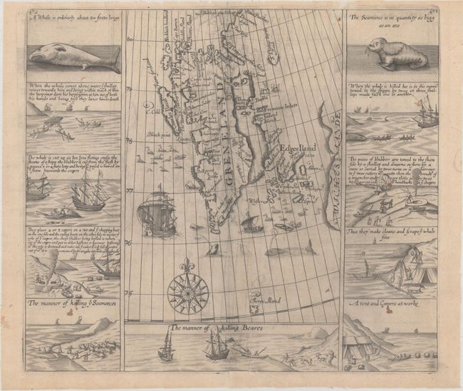
This map highlights the importance of the whaling industry to the English in the early 17th century. Expeditions by Willem Barentsz in 1596 and Henry Hudson in 1607 explored portions of Spitsbergen and noted the abundance of whales in the surrounding waters. Both the Dutch and English took note and began sending voyages to the island to hunt whales, walruses and polar bears. The Muscovy Company, who had been granted a monopoly charter on whaling in Spitsbergen by Queen Elizabeth I, sent a number of expeditions to the region, including those headed by Jonas Poole, Thomas Edge, and William Baffin. Letters and journals from these explorers found their way to Samuel Purchas, who incorporated their records in his Purchas his Pilgrimes, including a map of the known parts of Spitsbergen. On this map, Spitsbergen is erroneously named Greneland due to the English belief at the time that the land was connected to Greenland further north. Numerous English-based place names fill the map, some of which reflect explorers in the area, such as Edges Iland, Mount Edge, Sr Thomas Smyths Inlett, Charles Iland, and Hackluits Headland. Surrounding the map are eleven vignettes recording the manner of hunting and killing whales, walruses and polar bears. The term "seamorse" was used to denote walruses.
The Dutch, who were competing with the English for whaling rights in the region, were simultaneously publishing maps of Spitsbergen with Dutch toponyms. It wasn't until the whaling industry became of greater importance to the English and Dutch that maps focusing on Spitsbergen began to appear on the market. However, by the end of the 17th century, whaling interests had moved further west and individual maps of Spitsbergen were generally no longer included in atlases. As such, maps of Spitsbergen are relatively uncommon.
References: Pool (IMCoS Journal #121) pp. 35-42; Shirley (BL Atlases) G.PUR-1a #43.
Condition: B+
A dark impression on a lightly toned sheet with a small crown watermark. There is light offsetting, a few small stains, and a couple of tiny holes in the image caused by paper flaws. A 2" tear at bottom center has been professionally repaired on verso.