Subject: Western Hemisphere - America
Period: 1828 (dated)
Publication: Stielers Hand-Atlas
Color: Hand Color
Size:
11.4 x 15.1 inches
29 x 38.4 cm
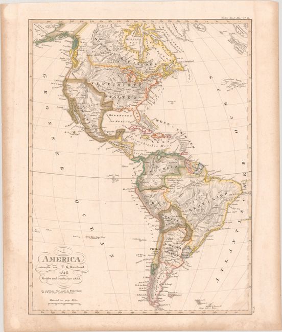
The United States and Great Britain established in 1818 joint claim over the Oregon Territory - the region north of Spanish controlled Upper California up to the southern boundary of Russia's Alaska Territory at North latitude 54°40'. By the late 1830's this arrangement was beginning to fall apart.
In the 1840's the expansionist Democrats, including their 1844 presidential candidate, James Polk, claimed the entire region for the United States. Their expansionist desires were expressed by Polk's famous campaign slogan, "Fifty-four Forty or Fight!" The slogan also became a rally cry for Americans desiring to settle the territory. Following Polk's election, the dispute was resolved by the 1846 Treaty of Oregon, which struck a compromise that fixed the U.S./Canadian boundary at 49º North.
This uncommon German map is a revised edition of Reichard's 1816 atlas map of the Americas, with updated boundaries between the United States, Mexico, and Canada. California, Texas (unnamed here), and the rest of the American Southwest are still Mexican possessions. Nacogdoches is the only place name in Texas. The Pacific Northwest is labeled Columbia Thal, with the United States extending into present-day British Columbia, a reflection of the Oregon boundary dispute; yet, the colorist of this example leaves the northern extent of the border uncolored, leaving the appearance of ambiguity. North of the border is West Caledonia. Ft. Mandon, Lewis and Clark's wintering spot in the winter of 1804-05, is located in Sioux country, east of Yellowstone. There are two large unnamed lakes north of the Colorado River with a city, S. Isabel, between them, and a conjectural River of the West connecting the southern lake to Fr. Drakes Bay. In South America, present-day Argentina is divided into La Plata Staaten and Magalhaens Land, and the Araucania region is delineated as separate from Chili.
References:
Condition: B+
Contemporary outline color with light dampstaining that enters the map image in the bottom corners.