Subject: World, World War II
Period: 1943 (dated)
Publication:
Color: Printed Color
Size:
34 x 42.8 inches
86.4 x 108.7 cm
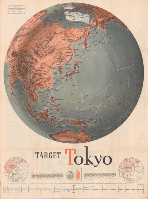
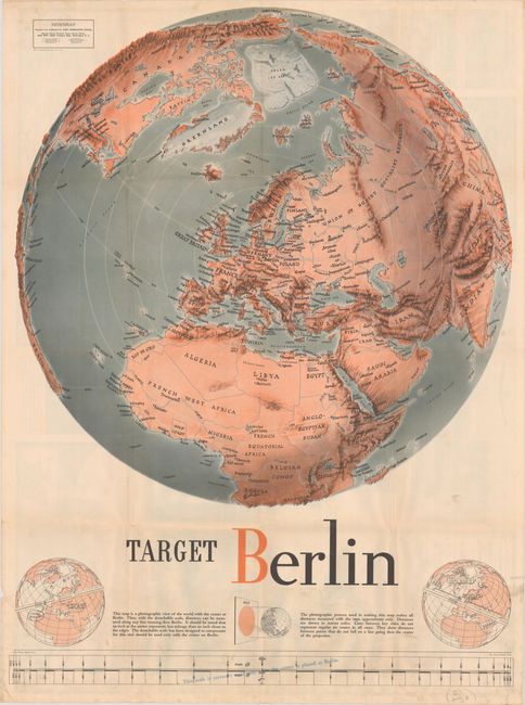
This lot contains two impressive pieces of World War II-era persuasive cartography centered on Tokyo and Berlin respectively. Each contains a detachable scale at bottom that can be used to measure distances along any line running through either city; two helpful diagrams at bottom demonstrate how to use it. Drawn by F.E. Manning.
Target Tokyo. This "photographic map" stretches from Scandinavia and Russia through Asia and across the Bering Strait to show Alaska and the west coast of North America down to San Francisco. The map also extends to include Australia, a large polar ice cap, and Greenland. Despite the map's title, at the time of the map's publication, there had been relatively few bombing raids on Japan aside from the 1942 Doolittle Raid. The heaviest strategic bombing campaigns on Japan came after the introduction of the B-29 Superfortress bomber in 1944.
Target Berlin. Although focused on Europe, this map stretches from Canada to northern Africa and northern Asia. The map also extends to include parts of the United States, a large polar ice cap, and Greenland. As the capital of Nazi Germany, Berlin was the target of numerous bombing raids throughout the war. The Battle of Berlin was launched just a few weeks after this poster was published, in which the city suffered 16 RAF air raids in just a few months.
These maps were two of the "newsmaps" published by the U.S. Army from 1942-46. They were designed to keep American troops updated on the war. The weekly posters were distributed and posted in every American installation in the world and were intentionally more visual than descriptive to help engage and motivate personnel.
References:
Condition: B+
Both maps are issued folding with a few small separations at fold intersections and along the sheet's edges and light soiling that is mostly confined to the blank margins. The Berlin map has an edge tear that extends 1" into the detachable scale at bottom.