Subject: Western United States
Period: 1837 (circa)
Publication: Irvings's The Rocky Mountains…
Color: Black & White
Size:
15.5 x 16.8 inches
39.4 x 42.7 cm
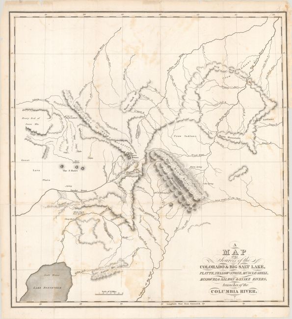
One of the most important maps of the intermountain west, it covers the present-day intersection of Idaho, Montana, Wyoming and Utah. Wheat considered the map the best representation of the region during this period. It shows the headwaters of the Wind, Sweetwater, Green (Colorado of the West), Snake, and Salmon Rivers relatively accurately, and completely revamps the hydrographical mapping of the region. Part of Lake Bonneville is shown at lower left and is noted as Salt Water. The vicinity of the Snake River is particularly well delineated with the Three Tetons, the 3 Buttes, and the Great Lava Plain well placed.
Captain Benjamin Bonneville's explorations in the America West (1832-35) were made famous by the account written by Washington Irving. The expedition sought information about the Oregon Country, which at the time was jointly occupied by the United States and Britain and largely controlled by the Hudson's Bay Company. Even though he was unable to complete his goal of reaching the Willamette Valley, he and members of his party were able to gather invaluable information on the region and blazed portions of both the Oregon and California Trails.
References: Wheat (TMW) #423; Howes #I-85.
Condition: B
Issued folding with some light scattered foxing and offsetting. A few short edge tears have been closed on verso with archival materials.