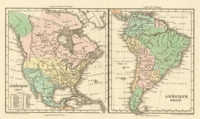
Subject: Western Hemisphere - America
Period: 1825 (published)
Publication: Atlas Geographique, Statistique, Historique ... des Deux Ameriques…
Color: Hand Color
Size:
14.9 x 8.3 inches
37.8 x 21.1 cm
Two maps on one sheet from the French edition of Carey & Lea's atlas. The maps each measure 8" x 8" and include North America (Amerique Sept.) and South America (Amerique Merid.). They are on a large folio sheet surrounded by panels of French text measuring 27.4 x 21.3". The United States is shown with the British claims into the Northwest down to the Columbia River, reflecting the 54-50 or Fight controversy. The states and organized territories are depicted with dotted lines (note the large Arkansas Territory). Mexico is in control of Texas and the present-day Southwest. Alaska is not fully shown and is a Russian Possession.
References:
Condition: A
Full contemporary color on a bright sheet with a worm track near the center of the image that has been archivally repaired on verso.