Subject: Pakistan & Afghanistan
Period: 1513 (circa)
Publication: Ptolemy's Geographia
Color: Black & White
Size:
20 x 15.9 inches
50.8 x 40.4 cm
Claudius Ptolemy was a mathematician, astronomer and geographer who worked in Alexandria, then a part of the Roman Empire, in the 2nd century AD. One of the most learned and influential men of his time, his theories dominated both astronomy and geography for nearly 1500 years. His writings were kept alive by Arabic scholars during the Middle Ages and reemerged in Europe during the Renaissance. The birth of printing led to wide dissemination of his great works on astronomy and geography. There were a number of editions of his Geographia beginning in 1477. These early editions contained maps based on his original writings, known as Ptolemaic maps. As geographic knowledge increased with the explorations of Columbus, Magellan, Cabot and others, maps of the New World were added, and maps of the Old World were revised. Ptolemy's Geographia continued to be revised and published by some of the most important cartographers including Martin Waldseemuller, Sebastian Munster, Giacomo Gastaldi, Jodocus Hondius, and Gerard Mercator (whose last edition was published in 1730).
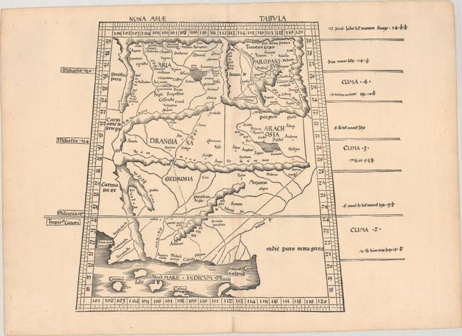
This striking woodblock map provides a Ptolemaic view of the region of present-day Pakistan and Afghanistan. The historic regions of Gedrosia, Drangia, Aria, Paropanisus, and Arachosia are prominently located with their rope-like mountainous boundaries. Waldseemuller's maps are among the most attractive and sought-after Ptolemaic maps.
References: Mickwitz & Miekkavaara #205-24.
Condition: A
A sharp impression on a bright sheet with a hint of toning along the centerfold and a short centerfold separation in the bottom margin.