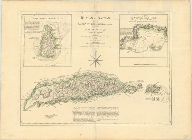
Subject: Roatan, Honduras
Period: 1779 (dated)
Publication: Pilote Americain
Color: Hand Color
Size:
23.8 x 18 inches
60.5 x 45.7 cm
Finely engraved chart featuring the island of Ruatan, known today as Roatan. In the 18th century New Port Royal was the location of a pirate settlement after an earthquake destroyed the original Port Royal in Jamaica. Two large insets: "Vieille Providence et Sta. Catalina" and "Port du Nouveau Port Royal." These charts are extremely detailed and show the locations of settlements, forts, reefs, safe harbors, and fresh water. A large compass rose occupies the center of the chart that was created by Lieutenant Henry Barnsley with improvements by Thomas Jefferys and issued here by Le Rouge.
References: Shirley (BL Atlases) M.LER-3a #12.
Condition: B+
Clean and crisp with contemporary outline color on a sheet with the watermarks of a Maltese cross encircled in rosary beads and "Dupuy Moyen Auvergne." There are some repairs in the margins, some creasing along the centerfold, and a couple of tiny wormholes on centerfold by the compass rose that have light tissue repairs on the face of the map.