Subject: Northwestern United States, Washington
Period: 1853-54 (dated)
Publication: U.S. Pacific Railroad Surveys
Color: Black & White
Size:
36.6 x 24.6 inches
93 x 62.5 cm
During the 1850s, the U.S. government sponsored an extensive series of expeditions designed to gather information on the vast new territories that had been acquired in western North America. The discovery of gold in California further stimulated westward traffic and heightened the need for a faster and more convenient way to bring the far-flung parts of the country together. In 1853 Congress commissioned the Army's Topographic Bureau to conduct a series of surveys to find a suitable route for a transcontinental railroad. There were six major expeditions; five of them covered the area between the Great Plains and west coast, and the sixth explored the coastal states of California and Oregon. All of these expeditions were accompanied by naturalists and artists to document the landscape, flora and fauna along the route.
The reports, maps and lithographs were published in the 13 volume report "Explorations and Surveys to ascertain the most practicable and economical route for a Railroad from the Mississippi river to the Pacific Ocean."
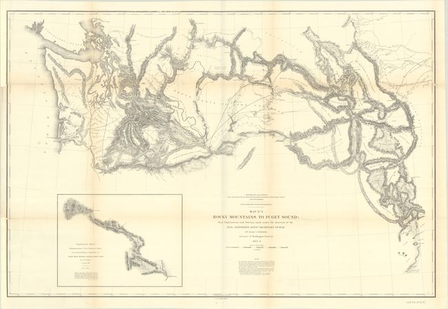
Wheat describes this excellent map as "the most complex of all that were made of Stevens' exploration. It details the many routes of McClellan, Gibbs, Donelson, Arnold, Saxton, and Mullan, to name just the majority of survey parties. It clearly indicates the great difficulty of finding a railroad route through the numerous mountain ranges. With a large inset of "Reconnaissance of the Railroad Route From Walla Walla to Seattle via Yak-e-mah River & Snoqualmie Pass." The map extends from the Strait of Juan de Fuca east to the Rocky Mountains to include Lewis & Clark Pass, Flathead Lake, and south to Fort Hall.
References: Wheat (TMW) #866.
Condition: B+
Issued folding, with light toning along the folds and binding trims in the left margin that have been replaced with paper. Fully backed in archival tissue to repair some fold separations and small chips and tears.