Catalog Archive
Auction 191, Lot 188

"Map of a Reconnaissance Between Baltimore and Philadelphia Exhibiting the Several Routes of the Mail-Road Contemplated by the Resolution of Congress Approved on the 4th of May 1826 [in report] Letter from the Postmaster General...", U.S. Government

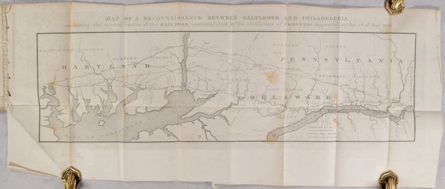
Subject: Maryland & Pennsylvania

Period: 1827 (published)

Publication: H.R. Doc. 94, 19th Congress, 2nd Session

Color: Black & White

Size:
31.2 x 9.2 inches
79.2 x 23.4 cm
Download High Resolution Image
(or just click on image to launch the Zoom viewer)

This early map provides a detailed picture of a strip of land 27 miles wide between Baltimore and Philadelphia, on a scale of three miles to the inch. It was issued by S. Bernard, Brigr. Genl. and William Tell Poussin, Capt. Top. Engrs, both on the Board of Internal Improvement. The map was a result of a Maryland petition for improvement of the existing mail road and shows several combinations of alternate post routes from Baltimore to Philadelphia. The map is oriented with north to the top right so that the possible routes could flow from left (Baltimore) to right (Philadelphia). Some roads are named and all are identified as projected, traveled or turnpike. The map is still bound into the original 19-page report and includes 6 large folding tables at the back describing in detail the various routes surveyed. Disbound and complete.

References: Claussen & Friis #7.

Condition: B

Light scattered foxing throughout. Disbound.

Estimate: $160 - $190

Sold for: $120

Closed on 2/8/2023

Archived