Subject: Colonial Eastern North America & West Indies
Period: 1722 (dated)
Publication:
Color: Hand Color
Size:
23.8 x 18.5 inches
60.5 x 47 cm
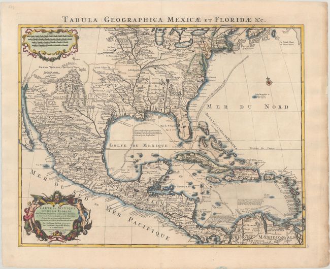
This is the Covens & Mortier issue of Delisle's important map that is credited with accurately showing the course of the Mississippi River and its mouth for the first time. The map correctly shows the Great Lakes region, the English settlements along the East Coast, and the early Spanish and Indian settlements in what are now Texas and New Mexico. The early native settlement of Checagou (Chicago) is named on Lake Michigan, called Lac des Ilinois after the native tribe. The name of Checagou refers to the wild garlic that grew abundantly there. Delisle's depiction of the Missouri River is a considerable improvement from his 1700 map of North America, shifting its course from due east to due northwest. Grand Teguaio habite par les Tiguas appears above the upper Rio Grande Valley. The southwest area of the map is mapped using Father Eusebio Kino's 1696 manuscript as a source. The map influenced later delineations of the Mississippi River by Seutter, Homann, Lotter, and others for many years. This edition has the route of the Spanish galleons added, and the title in Latin along the top margin.
References: Tooley (Amer) #51; Schwartz & Ehrenberg, plt. 82; Martin & Martin plt.17; cf. Brown (IMCOS #165) pp. 37-39; cf. Cummings (SE) #137.
Condition: A
A crisp impression on watermarked paper with a couple of short edge tears confined to the right blank margin that have been closed on verso with archival materials.