Subject: North America
Period: 1828 (dated)
Publication: Atlas Universel de Geographie...
Color: Hand Color
Size:
20.3 x 14.4 inches
51.6 x 36.6 cm
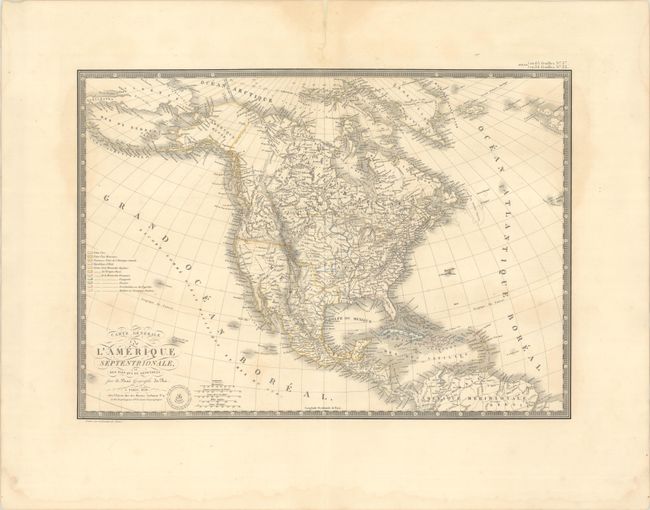
The United States and Great Britain established in 1818 joint claim over the Oregon Territory - the region north of Spanish controlled Upper California up to the southern boundary of Russia's Alaska Territory at North latitude 54°40'. By the late 1830's this arrangement was beginning to fall apart.
In the 1840's the expansionist Democrats, including their 1844 presidential candidate, James Polk, claimed the entire region for the United States. Their expansionist desires were expressed by Polk's famous campaign slogan, "Fifty-four Forty or Fight!" The slogan also became a rally cry for Americans desiring to settle the territory. Following Polk's election, the dispute was resolved by the 1846 Treaty of Oregon, which struck a compromise that fixed the U.S./Canadian boundary at 49º North.
This excellent map of North America and the West Indies features an embossed atlas seal below the script title. Alaska is Amerique Russe and still a bit misshapen. The United States is shown with the northern border of Oregon Territory bulging upward well into present-day British Columbia, reflecting the United States' claims in that region. Individual state and territorial borders are shown up to the Mississippi River, with a large Arkansas Territory extending above eastern Texas, still a part of Mexico. To the west of Michigan Territory is Terre. du Nord Ouest, with a number of Indian tribes named farther west. Surrounded by a keyboard style border.
References:
Condition: B+
Contemporary outline color with some light dampstaining and several archivally repaired centerfold separations at top.