Subject: North America
Period: 1856 (dated)
Publication:
Color: Hand Color
Size:
61 x 58.8 inches
154.9 x 149.4 cm
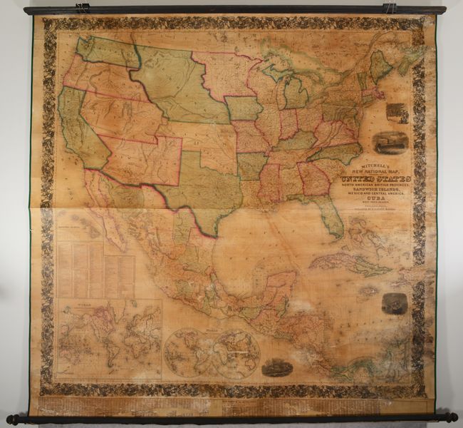
This is the first edition of Mitchell's epic wall map of North America. It shows the entire U.S. with some fascinating territorial borders in the West. Washington and Oregon extend to Nebraska Territory at the Continental Divide. Along the Canadian boundary, Nebraska Territory continues eastward to a large Minnesota Territory at the Missouri River. The huge territory of Utah encompasses all of Nevada and most of Colorado. New Mexico Territory includes all of Arizona, the southern tip of Nevada and a small portion of Colorado. Finally, a huge Kansas Territory shares its western border with Utah. Large inset maps of the Sandwich Islands, the world on Mercator's Projection, and the world in hemispheres. Several finely engraved vignettes flank the map including the "Clipper Ship Flying Cloud," and an "American Steamship Crossing the Atlantic." The map is very detailed with hundreds of place names, plus roads, villages, railroads, ports, and more. A large table at bottom gives the 1850 population for many U.S. cities. All surrounded by a wide decorative border.
References: Wheat (TMW) #896; Rumsey #2292.
Condition: B
Professionally conserved with new linen-backing and ribbon edging; original rollers are present and intact. There is moderate dampstaining and mildew spots along the right edge, with chips along the border at top right and bottom right replaced in facsimile, including a small portion of Colombia. As is typical for wall maps of this size, there are numerous abrasions, cracks, and small chips with some minor loss of image, most notably in the double hemisphere world map and the population table along the bottom. There is age toning from the varnish.