Subject: Western Europe, World War II
Period: 1943 (circa)
Publication:
Color: Printed Color
Size:
24.9 x 16.3 inches
63.2 x 41.4 cm
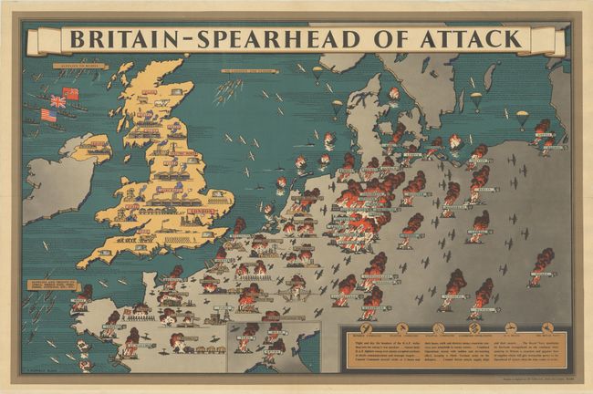
This map is part of a series published by the British Information Services in multiple languages for distribution both at home and abroad to provide assurance of Allied success in Europe. Created by Scottish artist Fredrich Donald Blake, this map depicts the successes of British attacks on mainland Europe and on ships in the surrounding waters. Cities, bridges, gasworks, airfields, troops, factories, and ships are shown as fiery bomb sites from France to Poland and the Czech Republic, with an inset showing the bombed cities of Turin, Milan and Genoa in Italy. As the text at bottom explains, "Night and Day the bombers of the R.A.F. strike deep into the enemy's war machine" and specific bombing targets, such as Philips Radio Works and Renault Works, are noted individually. Central Germany is illustrated as a giant sea of fire and Nazi cities are marked with a swastika.
In contrast to the gray and blazing mainland, Britain is depicted as sunny yellow and is filled with important resources for war, such as food, coal, and factories for ships, guns, aircraft, tanks, and electrical power. Additional supplies from the United States and Canada arrive on container ships to assure Britain "a ceaseless and gigantic flow of supplies which will give irresistible power to the Spearhead of Attack when the time comes to strike." Some supplies are shown diverted to Africa, the Middle East, India, Persia, Australia, and the cities of Lofoten and Vaagso in Norway, where British Operations Claymore and Archery successfully destroyed supplies headed for Germany.
This map was also published in French, Italian, Arabic and Persian. The British Information Services spearheaded the British propaganda effort and helped to pull the United States into the war. Printed by Alf Cooke Ltd., Leeds and London.
References: Curtis & Pedersen, pp. 176-179; PJ Mode Persuasive Map Collection #1315; Rumsey $14074.
Condition: A
A clean and bright example folded in quadrants, professionally backed in thin tissue to repair a couple of minor separations and tiny holes. There are a few light extraneous creases at top.