Subject: Greater Antilles, Portobello & Cartagena
Period: 1741 (circa)
Publication:
Color: Hand Color
Size:
20.8 x 17.6 inches
52.8 x 44.7 cm
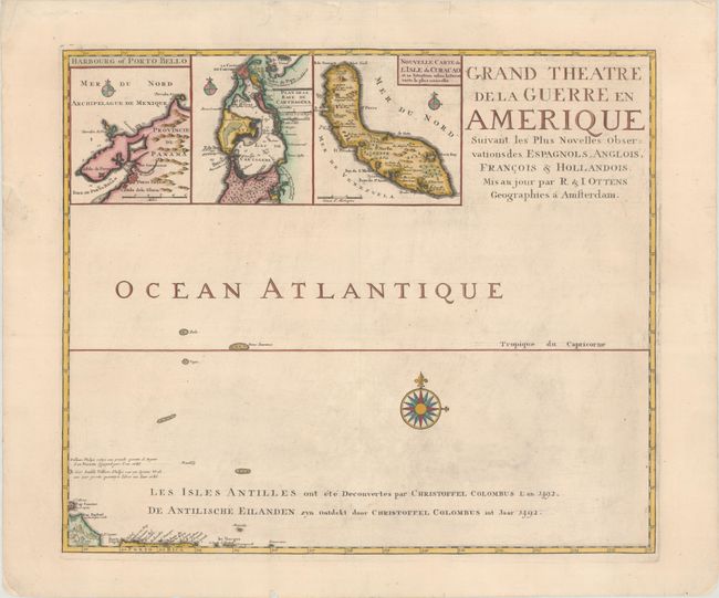
This is the northeastern sheet of Ottens' 6-sheet map of the Gulf of Mexico and the Caribbean depicting the theater of the War of Jenkins' Ear, part of the War of the Austrian Succession. The War of Jenkins' Ear had an improbable and theatrical origin. After fifty years of colonial boundary disputes and growing trade competition in the New World, relations between Britain and Spain were extremely strained. The war was named after Robert Jenkins, captain of the ship Rebecca, who claimed Spanish coast guards had cut off his ear in 1731. Seven years later Jenkins was invited by a party of warmongers to tell his story and display his ear to Parliament, thereby inflaming British and colonial American opinion against Spain. There was an increasing perception by the English that the Spanish were restricting their access to the slave trade in the West Indies. This friction was aggravated by a continuing dispute over the border between Spanish Florida and Georgia. These mounting issues compelled Prime Minister Walpole to declare war on Spain in October, 1739.
This map is the title sheet and depicts the Atlantic Ocean northeast of Hispaniola and Puerto Rico. Included are inset views of the important ports of Portobello, Panama and Cartagena, Colombia, as well as a map of Curaçao. The Tropic of Capricorn extends through the map, which is embellished with a large compass rose.
This map was first issued separately, as the Ottens' wanted to capitalize on the increased interest in the War of Jenkins' Ear, and published each sheet of the 6-sheet map as it was printed in 1740-41. The full set of 6 maps was not available until June 1741, and the individual maps were also included in made-to-order composite atlases. As a result, this map is not commonly found on the market.
References: Phillips (Atlases) #3495:117.
Condition: B+
A dark impression with minor toning, light soiling, a printer's crease at right, and some printer's ink residue. There are some short tears and chips along the edges of the sheet, most of which have been archivally repaired.