Subject: Colonial Southern United States
Period: 1744 (dated)
Publication: Charlevoix's Histoire et Description Generale de la Nouvelle France
Color: Black & White
Size:
17 x 8.3 inches
43.2 x 21.1 cm
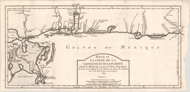
This important early chart of the Gulf Coast covers from New Orleans and the Mississippi delta to St. Marks River & Apalachicola Bay. The shoreline is still somewhat speculative but many harbors, inlets, bays & rivers are indicated along the coast. The Mississippi delta is well represented including the English Turn on the Mississippi River (Detour des Anglois). Shown mostly as a vast grassland, two areas noted as forests suitable for lumber are located near the abandoned French Fort de la Boulaye. Numerous Native American tribes and villages are located and the Choctaw Road to Natchez is partially shown in the upper left corner of the map. The map was drawn from manuscript sketches brought back to Paris by Pierre Francois Xavier de Charlevoix, a Jesuit Priest who traveled through the region from 1720-1722. Charlevoix's account was extremely influential in future decisions made by Thomas Jefferson with regard to the Louisiana Purchase and the exploration of the west.
References: Tooley (MCC-96) #719.
Condition: B+
Issued folding on a bright sheet of watermarked paper with light offsetting. There are two tiny dampstains along the right border.