Subject: Colonial Mid-Atlantic United States
Period: 1671 (published)
Publication: De Nieuwe en Onbekende Weereld
Color: Black & White
Size:
14.1 x 11.5 inches
35.8 x 29.2 cm
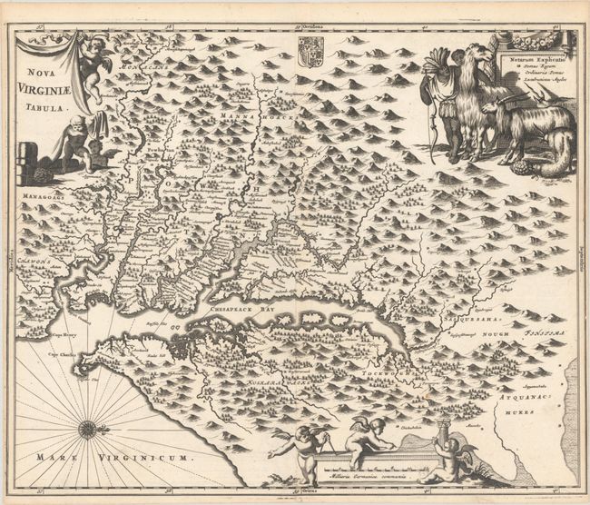
Montanus' work was perhaps the greatest illustrated book on the New World produced in the seventeenth century. It contained over one hundred beautifully engraved plates, views, and maps of North and South America. The plates vividly depict forts, festivals, occupations, Dutch fleets, battles, religious rites, and customs of the native inhabitants. This important work was translated into German by Olivier Dapper, and into English by John Ogilby. Several of the plates were later acquired by Pierre Vander Aa.
This is a very decorative, carefully made map based on the Hondius/Blaeu version of John Smith's prototype of Virginia and the Chesapeake Bay, and is considered state 8 of the Smith map. It is beautifully engraved by Jacob van Meurs with mountains, rivers, and forests and provides a wealth of information concerning the Indian villages in the region. The Potomac and Susquehanna Rivers are named, although the spelling differs. The James River is also shown, although is named Powhatan flu. The title and distance scale cartouches feature putti and a scene at upper right features Native Americans with a llama, a fat-tailed sheep, and other wildlife all believed to be native to Virginia. This is the first state of the map.
References: Burden #412; Goss (NA) #38; Tooley (Amer) p.168-9, plt. 76.
Condition: A
A strong impression on a clean bright sheet.